

Howes family roots
Article Contents
Besthorpe is the ancestral home of the Howes family. The line can be traced to this village/parish south west of Norwich, potentially as far back as the 15th century.
See Bottling it in Besthorpe for more about family connections to the area, and specific places such as The Carr, Bottle House, with census descriptions 1841-71 and map extracts for these.
Historic documents
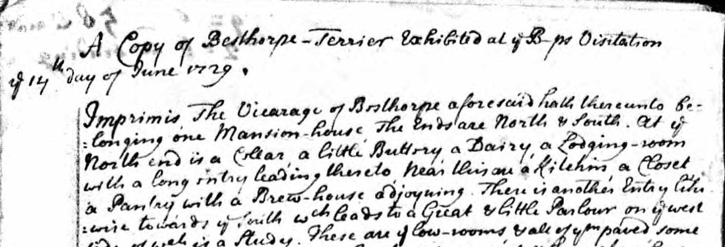
“Besthorpe Terrier”, Bishops Visitation 1729
The Besthorpe parish register from 1729 has as its first couple of pages ‘A copy of the Besthorpe Terrier exhibited at the Bishops Visitation 14th day of June 1729’. See the Cutlock & Co transcription (pdf, 434KB).
This document must be listing and describing the glebe lands, as mentioned in the 1854 directory below. Land names mentioned include Kennell’s Wood, Woodfield, New Close, Cock Close, Barn Close, Cales Close, Thaynes Close, Peaks-herne (?) Close, Scooty Land, Brickfield also known as Clamp Close. The register’s margins are used to total up the area owned, coming to 31 acres.

Land owners (and/or tenants) mentioned include: Charles Shaw (many times!), Andrew Wade, John Knight, Roger Cooper, Frances (Francis?) Thurling, John Howse ‘Gent’, John Cooper, Edward Osborne, Henry Curtis, Daniel Shearing, Joseph Hardingham.
Surely ‘John Howse Gent’ will be the person of that name identified elsewhere as John Howes of Morningthorpe, high sheriff of Norfolk in 1718.
Norfolk 1854 Whites Directory
BESTHORPE, 1 mile E. of Attleborough, is a parish with 134 scattered houses, 614 souls, and 2,132 acres of land, chiefly the property of the Earl of Winterton, the lord of the manor, impropriator of the rectorial tithes, and patron of the vicarage, valued in the King’s book at £5 6s. 10½d., and now enjoyed by the Hon. and Rev. A. A. Turnour, who has 28½ acres of glebe. The tithes are commuted for £255 to the vicar, and a like sum to the impropriator. The Church, a cruciform edifice, dedicated to All Saints, with a lofty tower and five bells, contains a beautiful marble monument to Sir C. Drury, Knt. The vicarage house is a neat modern erection, occupied by the curate, the Rev. E. W. Dowell, B.A. The Fuel Allotment 15a. 1r. 23p., is let for £17 6s. The Church Land, 4a. 3r. 16p., is let for £10 10s. DIRECTORY — Rev. Edwd. Wm. Dowell, B.A., curate, Vicarage; Jas Larkman, vict. Square and Compass, and blksmth; Robert Jas. Lovett and David Palmer, corn millers; Jas. Bayes, Louisa Jenny, and Edwd. Smith shopkeepers; Frances Wigget, blksmth; Jas. Doubleday, and David Palmer, beerhouses; W. Vinee, shoemkr; and Philip Alpe, Chs. Ayton, Thos Barker, Jas. Clarke, Jno. Cooke, Robt. Cowles, Mary Johnson, Edwd. Limmer (Hall), Geo. Minns, Burrell Page, Wm. Palmer, sen., Wm. Richd. Palmer, Reuben Reeve, Jonth. Turner, Jacob Vince, Jno. Warren, Michl. Warren, Wm. White, and Dnl. Wright, farmers.
The 1845 Whites directory entry has been transcribed on GenUKI. It includes: “The ancient Hall, now a farm-house, was a seat of the Drury family”. There are 35 acres of glebe, and in the list of farmers “Howes A., Exors. of”. 536 inhabitants.
Hundred of Shropham
Extracts from Hundred of Shropham section of The Churches of Norfolk, by Thomas Hugh Bryant and published 1913 (was available on Norfolk Sources which appears defunct, Dec.’22):
{Besthorpe} The children attend the Public Elementary School, erected as a National School in 1862, and afterwards enlarged to hold 110. There is a small Primitive Methodist Chapel in the village, erected in 1866.
{page 65/6} Besthorp is written “Besethorp” and Bestorp” in ancient documents. At the time of Domesday Survey (1086) this parish seems to have been divided into two parts viz Besethorp and Baconstorpe.
{p 65} Besthorpe Hall, formerly known as New Hall, is a building of red brick, erected in 1593 by Sir William Drury, as his Arms, and those of the Needhams, Viscount Kilmorrey, and the above date, appear on the east front.
{p 73} There were two Manor-houses, one called Old Hall or Plassing Hall, and New Hall, erected by the Drurys.
{page 65} The following is taken from the Norfolk Subsidy Roll of 15 Henry VIII: “Besthorp. Willms. Downey, gen. Valor £40; subsid. 40s. Isabelle Howys. Valor £60; subsid £3.”
{Section on land deeds, page 66}: William Jollye, of Besthorp, husbandman, is mentioned in a deed under Bunwell q.v., 30th September 1566. James Howse of Besthorpe, husbandman, in one under Wymondham, 30th September 1566. Emme Smyth alias Folsham of Besthorp, widow, under Wymondham, 30th September 1566.
{page 62?} The Hundred of Shropham is an irregular figure, about 14 miles in length, from Besthorpe to Thetford, and six to eight miles in breadth. It has an area of 48,359.490 acres fo land, and 237.260 acres of water (Ordnance Survey 1891) and had a population in 1881 of 8,596, in 1901 of 7,834 and in 1911 there were 8,104 inhabitants. The Hundred includes the parishes of Attleborough, Besthorpe, Brettenham, Bridgham, New Buckenham, Old Buckenham, Eccles, Great Ellingham, Hargham, Hockham, Illington, Kilverstone, Larling, Rockland All Saints and St. Andrews, Roudham, Shropham, Snetterton, Wilby, and East and West Wretham; these, with the Churches in the Hundred of Guiltcross, form the Deanery of Rockland (Northern and Southern Divisions). It is bounded on the North by the Hundreds of Wayland and Forehoe, on the South by Guiltcross, on the East by Depwade, and on the West by Grimshoe.
Also see
1880s 25 inch OS map on National Library of Scotland website.
Old maps and local statistical data on Vision of Britain. An 1870s gazetteer gives a population of 554.
Norfolk Heritage Explorer parish summary.
Norfolk Mills website’s page looking at Besthorpe Tower Mill.
Besthorpe (All Saints) church website.
Wikipedia page for the village.
Have something to add?